


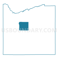
Voting District 200001, Cattaraugus County, New York
About
Outline

Summary
| Unique Area Identifier | 625700 |
| Name | Voting District 200001 |
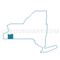
| County | Cattaraugus County |
| State | New York |
| Area (square miles) | 40.16 |
| Land Area (square miles) | 40.13 |
| Water Area (square miles) | 0.03 |
| % of Land Area | 99.92 |
| % of Water Area | 0.08 |
| Latitude of the Internal Point | 42.30460930 |
| Longtitude of the Internal Point | -78.76691840 |
Maps

Graphs
Select a template below for downloading or customizing gragh for Voting District 200001, Cattaraugus County, New York


Neighbors
Neighoring Voting District (by Name) Neighboring Voting District on the Map
- Voting District 070001, Cattaraugus County, NY
- Voting District 080002, Cattaraugus County, NY
- Voting District 120001 120002, Cattaraugus County, NY
- Voting District 170002, Cattaraugus County, NY
- Voting District 210001, Cattaraugus County, NY
- Voting District 220002, Cattaraugus County, NY
- Voting District 250001, Cattaraugus County, NY
Top 10 Neighboring County Subdivision (by Population) Neighboring County Subdivision on the Map
- Great Valley town, Cattaraugus County, NY (1,974)
- New Albion town, Cattaraugus County, NY (1,972)
- Little Valley town, Cattaraugus County, NY (1,740)
- Ellicottville town, Cattaraugus County, NY (1,598)
- Napoli town, Cattaraugus County, NY (1,248)
- East Otto town, Cattaraugus County, NY (1,062)
- Mansfield town, Cattaraugus County, NY (808)
- Otto town, Cattaraugus County, NY (808)
Top 10 Neighboring Unified School District (by Population) Neighboring Unified School District on the Map
- Cattaraugus-Little Valley Central School District, NY (6,675)
- Ellicottville Central School District, NY (3,462)
Top 10 Neighboring State Legislative District Lower Chamber (by Population) Neighboring State Legislative District Lower Chamber on the Map
Top 10 Neighboring State Legislative District Upper Chamber (by Population) Neighboring State Legislative District Upper Chamber on the Map
Top 10 Neighboring 111th Congressional District (by Population) Neighboring 111th Congressional District on the Map
Top 10 Neighboring Census Tract (by Population) Neighboring Census Tract on the Map
- Census Tract 9603, Cattaraugus County, NY (4,625)
- Census Tract 9606, Cattaraugus County, NY (3,427)
- Census Tract 9607.02, Cattaraugus County, NY (3,134)
Top 10 Neighboring 5-Digit ZIP Code Tabulation Area (by Population) Neighboring 5-Digit ZIP Code Tabulation Area on the Map
- 14779, NY (6,932)
- 14719, NY (3,497)
- 14755, NY (2,916)
- 14741, NY (1,873)
- 14731, NY (1,576)
- 14729, NY (948)